
San Juan Islands Directory.com
San Juan Islands Washington
San Juan Islands Marine State Parks
Marine State Park, DNR Park, Public Beaches, Island Parks that are accessible by boat.
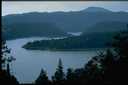
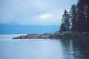
San Juan Islands Marine Parks. Not just Islands. Another World! Lush Forests and Abundant Sea Life.
A Wilderness Preserved for All to Enjoy.
San Juan Islands Public Beaches. Boat in Camping. Scuba Diving Locations. Boaters Attractions.
Listed here are the islands that DO and DO NOT have Washington State Ferry service.
However these islands are found 1/4 mi. - 2.5 mi from the ferry serviced islands.
If you do not have a boat there are boat and kayak rentals, charter boats in Anacortes on Orcas Island and San Juan Island, that will take you to these Island State Parks ans Marine Parks. Go to Orcas Island Directory homepage to find boat rental and boat charter information.
Always research your destination for the most up-to-date information. Check with the park service etc.
A prudent San Juan Islands boater should include tide tables and a navigation chart on board.
Several islands have campsites, toilets, mooring buoys and load / off load docks, mostly first come first served, fees may be charged, check if reservations are required; seasonal or year round. Contact info. below.
Most Islands have limited or NO drinking water. Take water with you and Please! Pack your garbage out.
Island activities include; camping, picnicking, saltwater fishing, shellfishing, scuba diving, biking trails and hiking trails.
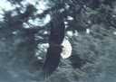
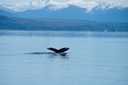
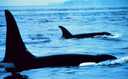
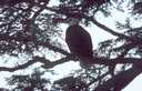
Island attractions include; historical sites, vantage points for bird watching, sightseeing, viewing wildlife, marine life.
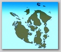
View Aerial Photos, follow the link by each island.
View Washington State Islands - Aerial Photos - San Juan Islands Aerial Photo Gallery
Enjoy your visit to the San Juan Islands. Please respect Private Property, Waterways and Critters.
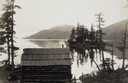
These San Juan Islands marine parks are accessible by boat.
NEW! Lieber Haven Resort and Marina at Obstruction Pass on on the SE side of Orcas Island has a 100 ft. guest dock. Private Boaters in the San Juan Islands may land at the guest dock N/C, and there is a sandy beach (rare in the islands) for kayaker's to land, N/C! You will find at Lieber Haven Resort and Marina a tourist information center, public phone, general store with groceries, ice, meats, beer, wine, island souvenirs, camping supplies, fishing supplies, charts, maps, some marine supplies, and internet service, wi-fi Hotspot!
( DNR Parks) Washington State Department of Natural Resources Parks
San Juan Islands Marine State Parks
 Cypress Island: Cypress Island is the largest undeveloped island in the San Juan Islands.
Cypress Island is located approx. 2 miles off the mainland of Anacortes Washington. 2.5 mi. off Orcas Island. Majority of Cypress Island is DNR land. DNR manages the island primarily for recreation. Cypress Island has a network of hiking trails, designated Cascadia Marine Trails that connect several areas of the island.Cypress has 3 public camping areas, lakes, and miles of hiking trails and abandoned roads.
Pelican Beach Recreation Area: Pelican Beach found on northeast shore of Cypress Island. Campsites pit toilets.
Cypress Head: A bar of sand tied to Cypress Island like a sandspit. Campsites and DNR recreation site with marine trail.
Eagle Harbor: Northeast side of Cypress Island. Unique rock formations. 880 FT. hiking trail leads to the peak for view.
Tide Point: West side of Cypress Island.
Secret Harbor: Southeast quarter in Deepwater Bay on Cypress Island is the small and shallow area of Secret Harbor. Atlantic salmon fish pens are there.
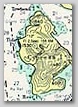
Further Information, Map of Cypress Island.... Pictures of Cypress Island WA. ...Island Aerial Photo
Strawberry Island Park: Strawberry Island located on the Southwest side of Cypress Island. The entire island is public property. Strawberry Island has campsites and picnic facilities are available. Popular for bird watching.
Further Information, Map of Strawberry Island.....Pictures Strawberry Island WA. ..Island Aerial Photo
Lummi Island: Lummi Island has an unmarked DNR Recreation Site located on the SE shore, approx. 1 mile from Reil Harbor. Lummi Island DNR park has campsites, 1 mooring buoy, pit toilets and picnic tables.This Lummi Island park is popular for San Juan Islands kayakers. Further Information, Map of Lummi Island.......Pictures Lummi Island WA.
Sinclair Island: Sinclair Island WA. is located 5 miles north of Anacortes, off the northern tip Cypress Island. Sinclair Island has a 45 ft. Dock, day-use only, 1 float is found on the southwest at the town of Urban. The dock provides public access however most of the shoreline is private. Popular for stretching the legs by walking the roads.
Further Information, Map of Sinclair Island.......Pictures Sinclair Island WA. Island Aerial Photo
Washington State Parks. Marine State Parks. San Juan County Area.
San Juan Islands Marine State Parks
San Juan Islands Marine Parks found on Orcas Island and close to Orcas Island WA.
......... ( Orcas Island has Washington State Ferry Service )
Orcas Island Marine Park:
 Obstruction Pass State Park: Obstruction Pass Park on Orcas Island is a hike in and a boat in camping park. Obstruction Pass Park is accessible by vechicle and boat. The park offers 11 campsites, 3 mooring buoys, fire pits. 80-acre Obstruction Pass State Park has a peaceful bay, popular activities include, fishing, hiking trails, tide pools and marine life viewing. There is a trail leading to restrooms in the parking area.
Map of Obstruction Pass Park.. Pictures of Obstruction Pass Park.. . Park Aerial Photos
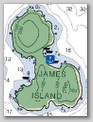 James Island State Park: James Island is located approx. 3.5 miles West from Washington Park (Fidalgo Island) across Rosario Strait. James Island is 113 acres has 3 camping areas. 13 campsites. Pit toilets. On the North shore of James Island there are several mooring buoys and a dock is located on the west side. The northern hill provides an especially wonderful view of the area. James Island has a designated Cascadia Marine Trail and many hiking trails and paths that weave across the high slopes. James Island popular activities, birdwatching, hiking trails, wildlife viewing and Deer. Map of James Island...Pictures James Island WA. ...Island Aerial Photos
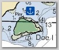 Doe Island State Park: Doe Island is a small island located approx. 1/4 mile off Orcas Island. Doe Island has 6 acres with a 44 foot pier. 5 campsites. One vault toilet. Activities on Doe Island include loop trail. Further Information, Map of Doe Island...... Pictures of Doe Island WA. ...Island Aerial Photos
 Clark Island State Park: Clark Island is located North East of Orcas Island. Clark Island is side by side with Barnes Island. Clark Island is long and has a sandy beach. There are mooring buoys between the two islands and in a cove on Clark Island's east side. Clark Island is a 55 acre island with 7 Campsites. Picnic tables. Pit toilets. 9 mooring buoys. Map of Clark Island... Pictures of Clark Island WA. ..Island Aerial Photos
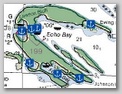 Sucia Island State Park: Sucia Island is located approx. 2.5 miles North of Orcas Island. Sucia Island, a horseshoe shaped island with a cluster of 11 tiny satellite islands. Many bays with nooks and crannies to explore. Almost tropical beaches. Sucia Island is 564 acres with two160 ft. docks and 48 mooring buoys. 3 separate campgrounds 55 campsites, 2 reservation group camps, 3 picnic shelters, 5 pit toilets and 9 composting toilets. Sucia Island has 6.2 miles of hiking trails. Popular activities include hiking, picnicking, clamming, crabbing, scuba diving. There is an underwater scuba park with one locator buoy. Sucia Island's Fossil Bay Map. Echo Bay Map. Fox Cove Map. Snoring Bay Map. Map of Sucia Island .... Pictures of Sucia Island WA. ....Island Aerial Photos
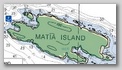 Matia Island State Park: Matia Island is located approx. 1.5 miles East of Sucia Island. Only 5 acres around Rolfe Cove on Matia Island are considered Marine State Park campground with the remaining 140 acres included in the San Juan Islands Wilderness. Matia Island has 6 campsites, composting toilet, 116-foot pier, 45-foot ramp, 2 buoys, No drinking water is available. Matia Island is popular for scuba diving and beachcombing, there is a 1 mile loop trail from the campground through an old-growth cedar forest. Matia Information, Map of Matia Island... Pictures of Matia Island WA. ...Matia Island Aerial Photo
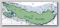 Patos Island State Park: Patos Island is located on the northern edge of the San Juan Islands. Patos Island is the most northerly island in the Pacific Northwest. The Island is 207 1/2 acres, 1 mile long island. Patos Island has 4 campsites. 2 buoys. Pit toilets. Popular Attraction on Patos Island is the Lighthouse, established in 1890. Current lighthouse structure built 1905. Patos Island has gentle hills, the views are stunning. Active Cove at the west end of Patos has the 2 mooring buoys. Map of Patos Island...... Pictures of Patos Island WA. ..Island Aerial Photos
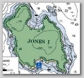 Jones Island State Park: Jones Island is located 2 miles to the East of Deer Harbor on Orcas Island. Jones Island has 188 acres with 25,000 feet of saltwater shoreline. The park has 21 campsites and a group site for up to 65 people. Picnic tables. Fire rings. Composting, vault and pit toilets. Several boat buoys and floats are available for overnight moorage. 1 dock. Jones Island popular activities, scuba diving, salt water fishing, clamming and oysters. Jones Island is inhabited by deer and other critters.
Further Information, Map of Jones Island.. Pictures of Jones Island WA. ..Island Aerial Photos
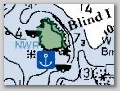 Blind Island State Park: Blind Island is located at the entrance to Blind Bay North side of Orcas Island. Blind Island is a 2 acre rock. Blind Island offers a few campsites, fire rings, 1 pit toilet and 4 mooring buoys.
Further Information, Map of Blind Island.... Pictures of Blind Island WA. ..Island Aerial Photos
Cone Islands State Park: The Cone Islands are located on the NE coast of Cypress Island. The Cone Islands consist of 5 small islands. There are 2 mooring buoys. The Cone Islands are noted as good scuba diving spots. Free Willy filmed the opening scene in 1992 near the Cone Islands. : Map of Cone Islands....Pictures of Cone Islands WA. ....Islands Aerial Photos
Skull Island State Park: Skull Island is located near West Sound on Orcas Island.
Skull Island is an undeveloped State Park. No overnight camping or fires are allowed. Skull Island is popular for kayakers and rowboaters to picnic. Map of Skull Island.. Pictures of Skull Island WA. ..Island Aerial Photos
Peapod Rocks: The Peapod Rocks are off the shore of Orcas Island near Doe Bay. No boaters are allowed to land anywhere. There is no anchorage. Peapod Rocks area is popular for diving and is designated an Underwater Recreational Area. I have included the Peapods for this reason.
Further Information, Map of Peapod Rocks...... Pictures of Peapod Rocks WA. ... Aerial Photo Peapod Rocks
San Juan Islands Marine Parks found on Lopez Island and close to Lopez Island WA.
........ ( Lopez Island has Washington State Ferry Service )
Lopez Island State Parks and Marine Parks:
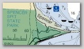 Spencer Spit State Park: Spencer Spit is located on Lopez Island. Spencer Spit Park is a 138 acre marine park and camping park acessible by vechile and boat. The Park is an enclosing lagoon sand spit. There are several sheltered and unsheltered picnic tables, 37 campsites, dump station, restrooms, fire pits and 16 mooring buoys. Spencer Spit is popular for clamming and crabbing.
Further Information, Map of Spencer Spit, Lopez Island...... Pictures of Spencer Spit, Lopez Island WA.
Iceberg Island State Park: Iceberg Island is located just around Iceberg Point at the South end of Lopez Island. Iceberg Island is an undeveloped State Park with no facilities. The bay close by is popular for agates, scuba diving and bird watching and is accessible by boat with pit toilets and picnic facilities.
Further Information, Map of Iceberg Island.. Pictures of Iceberg Island WA. ..Island Aerial Photos
Upright Channel State Park is a 20 acre, day-use park situated on Lopez Island. Further Information Upright Channel State Park
San Juan Islands Marine Parks found on San Juan Island and close to San Juan Island WA.
......... ( San Juan Island has Washington State Ferry Service )
San Juan Island Marine Park:
Griffin Bay: Griffin Bay Park is located on San Juan Island. Griffin Bay Park is a popular recreation site. The Park offers campsites, pit toilets numerous picnic tables and marine trail. The trail leading to the treeline is where you will find a campsite. Popular for kayakers, expect to tow your boat to camping area, you do not camp close to shore. No mooring buoys.
Further Information, Map of Griffin Bay...... Pictures of Griffin Bay San Juan Island WA.
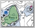 Turn Island State Park: Turn Island is located approx. 1/4 mile from northeastern tip of San Juan Island. Turn Island has 35 acres 10 campsites, 3 mooring buoys on the West side, but no dock. Turn Island has picnic tables, toilets, Turn Island popular activities include 3 miles of walking trails.
Further Information, Map of Turn Island... Pictures of Turn Island WA. ...Island Aerial Photo
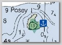 Posey Island State Park: Posey Island is located approx. 1/4 mile north of San Juan Island. Posey Island allows Nonmotorized boats only. Posey Island, a 1 acre island. No more than 16 people are permitted on the island at one time. Posey Island has 2 primitive campsites. Fire rings. Composting toilet. Popular for boat in camping, sunset views, quaintness and wildflowers. Further Information, Map of Posey Island...... Pictures of Posey Island WA.
 Stuart Island State Park: Stuart Island is located on the Northwest end of San Juan Island. Stuart Island has 2 well protected coves, Reid and Prevost harbors, they each have mooring buoys and floats provided by the state. Stuart Island is 153 acres with 22 primitive campsites, including 4 reserved for only nonmotorized boats, there are 22 buoys and floats, picnic tables, fire rings and composting toilets. Stuart Island is popular for boat in camping, kayaking trips from San Juan Island. Popular activities, hiking trails and viewing the abandoned Coast Guard lighthouse. Provost Harbor Map Reid Harbor Map Map of Stuart Island.. Pictures of Stuart Island WA. ..Island Aerial Photos
 San Juan Islands Maps, Aerial Photos: Washington State Dept. of Ecology
San Juan Islands Public Beach Map: Island Public Beaches
Pictures of San Juan Islands Wildlife and Marine life: Wildlife Pictures
San Juan Islands crabbing, clamming, shellfish and fishing Information and Regulations
 San Juan Islands History, Geology, Geography and Historical Sites:
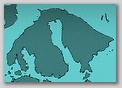
Museums, Explorers, Rock, Fossils, Plant Life, Marine Lif , Wildlife Information and Historical San Juan Islands Map including Puget Sound Map. San Juan Islands History, Historical Map of the San Juan Islands
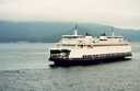 Current San Juan Islands Ferry Schedule www.sanjuanislandsferryschedule.com
Lopez Island, Shaw Island, Orcas Island, San Juan Island Ferry Schedule.
View Pictures of San Juan Islands Ferries, Ferry Route Map, Ferry Terminal Cams and More!
When you purchase your WSF ticket you are paying for a round trip ticket. On your way back to Anacortes (eastbound) you can get off and visit any island for as long as you want. As long as you are going Eastbound there is no charge to get on and off the Ferry.
 San Juan Islands Weather Forecast
San Juan Island Marine Forecast NOAA
San Juan Islands Tide Tables, Washington State Tide Tables WA.
Washington State Parks: Assist with questions regarding specific parks, passes, permits,
overnight accommodations, recreation programs and seasonal park closures. WEBSITE
Information Phone: (360) 902-8844 E-mail: infocent@parks.wa.gov
Reservations: Phone: (888) CAMPOUT or (888) 226-7688
Mailing address: Washington State Parks and Recreation Commission
7150 Cleanwater Lane, P.O. Box 42650 Olympia, WA 98504-2650
Plot your course to visit the San Juan Islands.
Take a cruise through
Orcas Island Directory .Com
Orcas Island Visitor Information and Business Directory w/links.
Find San Juan Islands lodging, dining, whale watching, kayak rentals, kayak tours, boat charters,
maps, pictures, news, attractions, activities including history of the San Juan Islands.
Orcas Island Directory; San Juan Islands Washington Information at you fingertips!
www.orcasislanddirectory.com
copy right 2002---2013 all rights reserved
World Wide Web Portal to San Juan Islands WA.
Orcas Island Directory
Maintained by Orcas Island Studios (360)-376-2472---ask for DAVE
Orcas Island, WA.
COPYRIGHT 2002---2012 all rights reserved
Lieberhaven Resort
Disclaimer: If you notice that a link does not deliver on what it promises, don't be alarmed,
I am working on it and I will have all links on this page completed shortly. please visit again.
In establishing the hypertext links on this page we do not represent in any way,
expressly or by implication, that we have received endorsement, sponsorship or support for this Site.
The links provided are to references, for further details and information sources.
Orcas Island Studios makes no claims, promises or guarantees about the accuracy, or adequacy of the contents.
Do not rely on maps or any information presented.CONTENT LIABILITY: READ